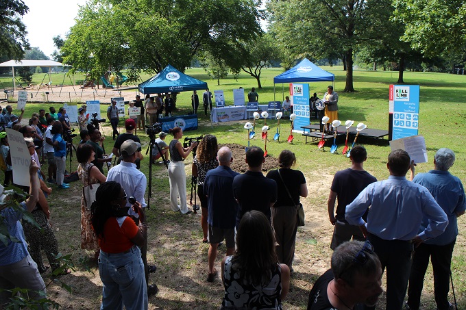
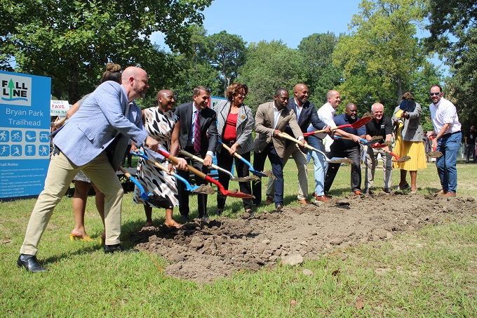
Wednesday’s ceremony drew a crowd of trail supporters and opponents of the route through Bryan Park, some of whom held up signs throughout the event. (Jonathan Spiers photos)
Work on the multijurisdictional Fall Line Trail is making its way into Richmond city limits, though not everyone on hand for a ceremonial groundbreaking was celebrating the multiuse path’s planned route.
City officials and supporters of the years-in-the-making trail converged on Bryan Park Wednesday to mark the start of construction of Richmond’s 13-mile portion of the 43-mile trail that’s planned to run between Ashland and Petersburg.
The event followed similar groundbreakings over the past year by Henrico and Hanover counties, which along with Richmond are among nine jurisdictions that make up the trail’s path and have provided support for the regional project.
With Wednesday’s groundbreaking, construction is officially underway in over half of those localities, according to Sports Backers, the nonprofit group that’s spearheading the project.
Bryan Park will be the trail’s northern access into Richmond and will serve as one of three trailheads in the city, along with Kanawha Plaza and a to-be-determined location on Commerce Road. The Bryan Park trailhead will provide parking, restrooms and access to park amenities, and the trail will be routed along the park’s main spine road via a new path beside the playground and soccer fields.
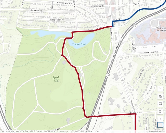
A map of the route through Bryan Park shows where the trail will veer off existing roads. (Image courtesy FallLineTrail.org)
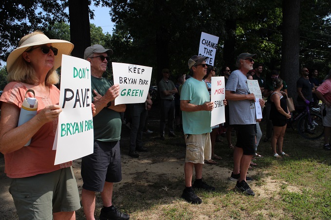
It’s that route that’s the rub for a group calling themselves Citizens for a Responsible Fall Line Trail, several of whom were on hand for Wednesday’s ceremony and held signs saying “Don’t pave Bryan Park,” “Change the route” and “No more asphalt.”
Elizabeth Barrett, a nearby resident who is part of the group, said after the event that it doesn’t oppose the trail or the project, just the route. The group says the new path is unnecessary in light of available roads in the park and the route will remove trees and greenspace and run through an already highly trafficked area.
“It’s too close to the soccer fields. How are we going to protect kids from just running through there, bicyclists going through? There are hundreds of people on Saturday and Sunday when they have the soccer games,” Barrett said.
“There’s existing pavement already. Use it,” she said. “Don’t do something environmentally destructive, to a park of all places.”
Jon Lugbill, Sports Backers’ executive director, told BizSense that the route was selected, with input from city parks staff, specifically for its proximity to those amenities. He said an earlier route considered would have run through an unused portion of the park, but he said safety and visibility concerns led Richmond’s Parks & Recreation Department to favor the current route.
“I think their idea was that the Fall Line Trail would serve as a way for people to bike and walk to the park and take advantage of the park amenities – all of them, not just the trail in the back,” Lugbill said.
“It was chosen to go by a bathroom to service the trailhead,” he added. “It was chosen to go by a playground for the people who want to bike, walk or run to a playground with their kids. It was chosen to go near the soccer fields for people that didn’t have to drive there. It was chosen to go near the parking lot so that people could park and then access the trail.”
Regarding concerns over congestion between trail and park users, particularly visitors needing to cross the trail to access the fields and parking, Lugbill likened the scenario to Richmond’s Potterfield bridge crossing the James River downtown.
“When you’re biking, you’ve got to be aware of people. You bike slower. I think that is what might happen for a stretch of the trail in Bryan Park, and to us, that’s a good thing,” he said. “Potterfield is a bad experience if you’re trying to go fast, but it’s a wonderful bridge for people to bike on and the views are spectacular and it’s worth the conflict that exists with pedestrians.”
After Wednesday’s ceremony, Richmond public works staff led a walk of the route to discuss its rationale and impacts. While the route will require new construction for the trail, officials maintained that environmental impacts to the park would be minimal.
Among those who gave remarks were Richmond Parks & Recreation Director Chris Frelke, who reiterated concerns about safety and accessibility.
“A lot of individuals might not feel safe going into certain areas of this park, because of historical things that have happened,” he said. “When we create trails like this, we need to put it in prominent areas so people feel safe as they use these different amenities within the park. We want everyone to feel welcomed in the park; we want everyone to feel safe.”
Mayor Levar Stoney said the trail would not only improve access but also be a catalyst for economic development.
“Where some segments of the Fall Line Trail will utilize existing bike lanes, much of the trail will feature new construction and enhancements meant to make our streets friendlier for families and tourists as they bike and stroll through our city,” Stoney said.
“Trails like this in cities like Indianapolis and Atlanta have provided economic development growth as well. This will not just simply traverse through Bryan Park but it will go through downtown Richmond, it will go through Southside as well, and along this trail you will see an amazing amount of growth,” he said. “Yes, this is a parks and transportation project, but this is a community project.”
A timeline for the Bryan Park trailhead and the city’s portion of the trail was not provided Wednesday. The entire 43-mile trail is targeted for completion by 2034, though sections are expected to be completed sooner, including a 13-mile stretch from Richmond to Ashland in the next few years.
The Bryan Park segment will connect with another trailhead planned at 4921 Lakeside Ave., a former bank building that Henrico purchased last year and is set to be Sports Backers’ new HQ. Internal demolition for that project got underway this week, and Lugbill said the group expects to move there in January.
Henrico also has completed initial portions of its part of the trail and has installed a signalized crossing on Lakeside Avenue between the Sports Backers building and Bryan Park.
The Central Virginia Transportation Authority is the main funder of the overall Fall Line project, which is anticipated to cost more than $400 million.

Wednesday’s ceremony drew a crowd of trail supporters and opponents of the route through Bryan Park, some of whom held up signs throughout the event. (Jonathan Spiers photos)
Work on the multijurisdictional Fall Line Trail is making its way into Richmond city limits, though not everyone on hand for a ceremonial groundbreaking was celebrating the multiuse path’s planned route.
City officials and supporters of the years-in-the-making trail converged on Bryan Park Wednesday to mark the start of construction of Richmond’s 13-mile portion of the 43-mile trail that’s planned to run between Ashland and Petersburg.
The event followed similar groundbreakings over the past year by Henrico and Hanover counties, which along with Richmond are among nine jurisdictions that make up the trail’s path and have provided support for the regional project.
With Wednesday’s groundbreaking, construction is officially underway in over half of those localities, according to Sports Backers, the nonprofit group that’s spearheading the project.
Bryan Park will be the trail’s northern access into Richmond and will serve as one of three trailheads in the city, along with Kanawha Plaza and a to-be-determined location on Commerce Road. The Bryan Park trailhead will provide parking, restrooms and access to park amenities, and the trail will be routed along the park’s main spine road via a new path beside the playground and soccer fields.

A map of the route through Bryan Park shows where the trail will veer off existing roads. (Image courtesy FallLineTrail.org)
It’s that route that’s the rub for a group calling themselves Citizens for a Responsible Fall Line Trail, several of whom were on hand for Wednesday’s ceremony and held signs saying “Don’t pave Bryan Park,” “Change the route” and “No more asphalt.”
Elizabeth Barrett, a nearby resident who is part of the group, said after the event that it doesn’t oppose the trail or the project, just the route. The group says the new path is unnecessary in light of available roads in the park and the route will remove trees and greenspace and run through an already highly trafficked area.
“It’s too close to the soccer fields. How are we going to protect kids from just running through there, bicyclists going through? There are hundreds of people on Saturday and Sunday when they have the soccer games,” Barrett said.
“There’s existing pavement already. Use it,” she said. “Don’t do something environmentally destructive, to a park of all places.”
Jon Lugbill, Sports Backers’ executive director, told BizSense that the route was selected, with input from city parks staff, specifically for its proximity to those amenities. He said an earlier route considered would have run through an unused portion of the park, but he said safety and visibility concerns led Richmond’s Parks & Recreation Department to favor the current route.
“I think their idea was that the Fall Line Trail would serve as a way for people to bike and walk to the park and take advantage of the park amenities – all of them, not just the trail in the back,” Lugbill said.
“It was chosen to go by a bathroom to service the trailhead,” he added. “It was chosen to go by a playground for the people who want to bike, walk or run to a playground with their kids. It was chosen to go near the soccer fields for people that didn’t have to drive there. It was chosen to go near the parking lot so that people could park and then access the trail.”
Regarding concerns over congestion between trail and park users, particularly visitors needing to cross the trail to access the fields and parking, Lugbill likened the scenario to Richmond’s Potterfield bridge crossing the James River downtown.
“When you’re biking, you’ve got to be aware of people. You bike slower. I think that is what might happen for a stretch of the trail in Bryan Park, and to us, that’s a good thing,” he said. “Potterfield is a bad experience if you’re trying to go fast, but it’s a wonderful bridge for people to bike on and the views are spectacular and it’s worth the conflict that exists with pedestrians.”
After Wednesday’s ceremony, Richmond public works staff led a walk of the route to discuss its rationale and impacts. While the route will require new construction for the trail, officials maintained that environmental impacts to the park would be minimal.
Among those who gave remarks were Richmond Parks & Recreation Director Chris Frelke, who reiterated concerns about safety and accessibility.
“A lot of individuals might not feel safe going into certain areas of this park, because of historical things that have happened,” he said. “When we create trails like this, we need to put it in prominent areas so people feel safe as they use these different amenities within the park. We want everyone to feel welcomed in the park; we want everyone to feel safe.”
Mayor Levar Stoney said the trail would not only improve access but also be a catalyst for economic development.
“Where some segments of the Fall Line Trail will utilize existing bike lanes, much of the trail will feature new construction and enhancements meant to make our streets friendlier for families and tourists as they bike and stroll through our city,” Stoney said.
“Trails like this in cities like Indianapolis and Atlanta have provided economic development growth as well. This will not just simply traverse through Bryan Park but it will go through downtown Richmond, it will go through Southside as well, and along this trail you will see an amazing amount of growth,” he said. “Yes, this is a parks and transportation project, but this is a community project.”
A timeline for the Bryan Park trailhead and the city’s portion of the trail was not provided Wednesday. The entire 43-mile trail is targeted for completion by 2034, though sections are expected to be completed sooner, including a 13-mile stretch from Richmond to Ashland in the next few years.
The Bryan Park segment will connect with another trailhead planned at 4921 Lakeside Ave., a former bank building that Henrico purchased last year and is set to be Sports Backers’ new HQ. Internal demolition for that project got underway this week, and Lugbill said the group expects to move there in January.
Henrico also has completed initial portions of its part of the trail and has installed a signalized crossing on Lakeside Avenue between the Sports Backers building and Bryan Park.
The Central Virginia Transportation Authority is the main funder of the overall Fall Line project, which is anticipated to cost more than $400 million.




There is no doubt in my mind that this will become a beloved part of the park and that all the NIMPs (Not In My Park) will just disappear.
This, exactly. The amount of new pavement being added is negligible compared to the size of the park and delivering a tremendous benefit in return. The disc golf course at BP is acres upon acres of overwhelmingly green space – and not changing at all.
BP would benefit from more pickleball courts. Would these same naysayers object to the asphalt required for that too?
Don’t hold your breath. Critics of the rushed and poorly conceived trail route will be around for a while. We’ll be there when the city eventually spends more money to reroute the trail because of safety issues just like they rerouted sections of the VCT.
“ Jon Lugbill, Sports Backers’ executive director, told BizSense that the route was selected, with input from city parks staff…”
Has anyone seen these staff? Usually around 20 stone and bound to a motorized conveyance
20 stone? Are you trolling people in America from the UK?
This would explain why you think downtown isnt safe
The trail is reminiscent of the Old Dominion Trail that runs from Purcellville in Loudoun County to the Key Bridge crossing of the Potomac and ties into the Parkway trail that runs to Mt. Vernon. Since its opening additional connecting trails have been committed and built along creeks that traverse subdivisions all over Fairfax County, providing cyclists and pedestrians routes to enjoy without having to use major thoroughfares. It’s a wonderful system. It’s so much better than forcing bike routes in the urban grid where they don’t belong and have failed to attract use ala Floyd Avenue in the Fan.
Exactly! I don’t feel 100 percent safe on Floyd, especially approaching the roundabouts. The trail will create an amazing grid that those new to biking will use. New to cycling folks will not go on urban streets. This is a win win for the region, helping to improve tourism as well as quality of life for residents.
Bruce Milam/Lee Clark, how do you propose that people access the FLT and other paths without on-street connections? And how is the FLT a “grid”? It’s a linear route that doesn’t serve many destinations nor provide broad access without utilizing the street grid. As for bike routes not belonging on urban streets? Say what? So urban streets, including those in residential neighborhoods are the sole domain of the car? And the assertion that bike routes don’t attract use is false. Floyd saw an increase in bike traffic. The Franklin Street “cycletrack” bike lanes see hundreds of bicyclists per day, and… Read more »
Grove Avenue is still the favorite route for cyclists from Three Chopt to Harrison. It’s a straight route with a crossing over the expressway. The Floyd route requires detours. By forcing the bike route to Floyd and the construction of the BS roundabouts to discourage truck traffic, Grove Avenue was left to absorb the increase in traffic, especially large trucks, transforming a natural cycling route into a dangerous one. It had nothing to do with safe cycling and all to do with re-routing noisy trucks to Grove Avenue.
The FLT route as proposed through the city is not remotely like W&OD which uses mostly abandoned rail lines. The city’s plan follows existing streets almost the entire length, even through the park. The city didn’t even evaluate using rail or power-line rights-of-way to steer trail users away from congested streets and hazardous intersections.
“Bike routes don’t below in the urban grid”
Yes, everyone knows the only sensible and efficient place where bikes belong are the areas with no density where things are as far apart of possible.
Bikes belong anywhere a car goes, and then some.
I can’t wait for the Southside development of the trail! It has potential to be the catalyst that sparks development further south along Commerce Road complimenting the already rapid growth of Manchester. It will also serve as a great connector of the Oak Grove/Bellemeade neighborhoods to Manchester and the entire James River Park System.
Citizens’ input ignored? Gee, that never happens in Richmond.
https://www.oregonhill.net/2019/03/24/east-coast-greenway-and-atp-trail-study/
Query – does listening to citizen input mean you have to agree with it or follow it? I mean what about the citizens that favor the new route – many of who seem to be posting and down-voting your comment in this very thread. Many people only seem to care about citizen input when they are the citizen whose input is being followed.
Connecting the trail to the park was a wise decision, despite the naysayers. I’m looking forward to riding my bike to the farmer’s market safely and efficiently.
The issue isn’t connecting to the park. The issue is adding more paved paths in green space!
The benefit of having a separate pathway means that maintenance is easier to perform and it provides a multi-use path just for walking or biking, not sharing the road with cars. I understand the concern regarding pavement, but logistically it makes more sense to have a separate path. Perhaps since we will have enhanced mobility now, we can consider removing a parking lot from the park and planting a wildflower garden in its place, that will certainly help in reducing the pavement in Bryan Park. We also need to keep in mind that we can’t let perfection be the enemy… Read more »
Some reading comp required. They are not objecting to the connection/extension, only the manner:
“Elizabeth Barrett, a nearby resident who is part of the group, said after the event that it doesn’t oppose the trail or the project, just the route. The group says the new path is unnecessary in light of available roads in the park and the route will remove trees and greenspace and run through an already highly trafficked area.”
The point of the trail is to connect amenities so people can have an alternative to cars in their daily lives. This is infrastructure. This means putting the trail where the amenities are, not elsewhere.
It means paving because Americans are resistant to walking in green space. They demand to have something pushing them through it. Something to make nature easier and tamed.
Add bike lanes and walking paths along existing pavement.
Heaven forbid you look at the map and rightly conclude that cyclists and hikers can’t be expected to traverse a few yards off existing roads to… the amenities!!! All the amenities!!! No they need a new path right to it.
If you use Bellevue Ave to get to the market you probably won’t notice much difference except more bike traffic in an already highly congested area. I went on the walk-through with the various representatives and saw how the trail will enter below shelter 1 and run up through the middle of the existing green space with paved roads on either side. The trailhead will be at the new bathroom and then go past the playground. It will run between the line of trees and the soccer fields and then go on the existing road to the Bellevue bridge. When… Read more »
I don’t mind the route through the park but some serious concerns about tree canopy and the tree roots. City contractors in parks (even for park improvement project) have a history of causing long term damage to trees when they build stuff out. I do like the overall park route but I hope they go around some of the older trees and their root systems AND do everything to protect trees during construction.
The statement from Jon Lugbill does not appear to be accurate. The initial route of the trail was to bypass the park entirely by using the existing bike lanes on Hermitage. Henrico requested the park detour. The first VDOT option for travel through the park went through an even more congested and environmentally damaging path. The city parks folks working with the Friends group were the driving forces to have the current route be slightly safer and less environmentally destructive.
Surely everyone arguing this strongly supports turning some of the current pavement back into gravel/trees and limiting car access.
“It’s too close to the soccer fields. How are we going to protect kids from just running through there, bicyclists going through? There are hundreds of people on Saturday and Sunday when they have the soccer games,” Barrett said.
I don’t know Elizabeth, how are we going to protect kids from just running through there, people driving 6000 lb Dodge Rams going through?
The road is not within a few feet of the soccer fields. The proposed bike path however is. As is the playground. The people who use the park every single day should have had a major voice in planning the route through the park. It is very bizarre that the main reason given to put the route where they have planned is because people do not feel safe at the park. So very odd. Obviously the people who are there everyday feel safe. And a populated bike route around the park would make it even safer for all of the… Read more »