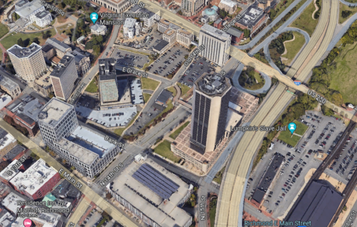
The “Eastern Quadrant” of Capitol Square is defined by Governor Street on the west, Interstate 95 on the east, East Broad Street on the north and East Main Street to the south.
Editor’s note: This is the second of a two-part commentary on the history of Capitol Square’s Eastern Quadrant and ideas for its reinvigoration. Click here to read part one.
Taxes, schools, abortion, the minimum wage. All are hot-button issues as the Virginia General Assembly’s 2024 session winds into the home stretch. Also pressing is a $2 billion bond proposal to transform the City of Alexandria’s Potomac Yards into an ambitious multiuse development. A centerpiece would be a hockey and basketball arena for the Capitals and Washington Wizards.
But currently, with the completion of a sparkling new legislative office tower and the Old City Hall renovation, the state is quietly exploring the redevelopment of other parts of Capitol Square’s historically rich, 46-acre campus.
An intriguing corner of the contiguous 46-acre tract is an all-but-hidden, geographically challenging site known as the Eastern Quadrant. The 8-acre area is defined by East Broad, East Franklin and Governor streets and Interstate 95. The hillside is defined by three architecturally brutal high-rise state office buildings and surface parking lots. Way, way back in the day, until the 1920s, this moribund western slope of Shockoe Valley was known as Council Chamber Hill. It was a community abuzz with government buildings, a few grand houses and hotels. Some small businesses constituted a thriving red-light district.
Considering the potential for such an underutilized site within yards of the iconic Capitol, below are some suggestions for how these 8 acres might be revitalized and brought up to snuff with the statehouse and its immediate grounds. These ideas include reopening Governor Street partially to public vehicular traffic, constructing infill office structures at the top of the hill and establishing a park-like grand promenade that would crown and celebrate the old hillside architecturally while offering vistas of other Richmond hills and landmarks.
First off, gently winding Governor Street now mitigates the somber office towers and asphalt lots of the Eastern Quadrant. It’s an evocative thoroughfare that’s currently closed to public traffic. Reopening and enlivening the spaces along this street will be key to the neighborhood becoming a worthy accompaniment to magnificent Capitol Square itself.
In the late 18th century, Governor Street was a rutted country road connecting commercial Shockoe Slip with Broad Street on the peak of Council Chamber Hill. This was before the establishment of the city’s rectangular street grid. The temple-form First Baptist Church (built in 1841 and now a student center on Virginia Commonwealth University’s health campus) still maintains its hilltop perch on the axis with Governor Street.
Since 1813, the cow path-turned-street has skirted the rear of the Executive Mansion, the nation’s oldest gubernatorial residence still in use. Unfortunately, the old roadway has been closed to public vehicular traffic in recent years and is now a de facto parking lot for state employees. Adding insult to injury is the clunky-looking gateway and related security apparatus that make up a vehicle checkpoint where Governor meets East Broad Street. Navigating this obstacle course is no way for pedestrians to enter Capitol Square, the 232-year-old government center of the commonwealth. This checkpoint, situated between the state’s Patrick Henry Building and VCU’s Memorial Hospital, will also be a primary entry point for those approaching the reworked Eastern Quadrant.
But, once past these security barriers, Governor Street becomes a charming downhill experience. Well, almost (those darned parked cars).
The Capitol Square/western side of the street possesses a handsome and continuous urban wall composed of various elements that runs downhill to Shockoe Slip. The first element is a rusticated stone retaining wall that supports a 200-year-old, spikey cast iron fence that delineates the rear of the Executive Mansion compound. After the wall, the stately looking rear facade of the state’s Oliver Hill Building annex (a 2004 addition to the original 1894 building faces Governor Street). Next comes a set of almost hidden outdoor staircases that lead up to lower Capitol Square, where a walkway snakes past the Jefferson, Washington and Hill buildings.
Finally, across Bank Street, the well-tailored eastern wall of the Virginia Retirement System headquarters extends to the Governor Street and East Main Street sidewalk.
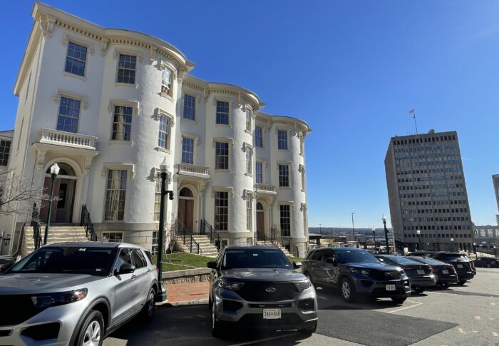
On the eastern side of Governor Street, VCU’s Memorial Hospital (built in 1900) anchors the southeast corner of East Broad. Heading downhill is Morson’s Row (built 1853), three exquisite, Italianate-style townhouses. This architectural showstopper was recently restored and awaits state office use. But beyond this jewel things come to a thud: surface parking lots.
These extend eastward along East Grace to Old 14th Street and beyond to a bluff overlooking North 14th Street and the state’s looming Monroe Building, the city’s tallest.
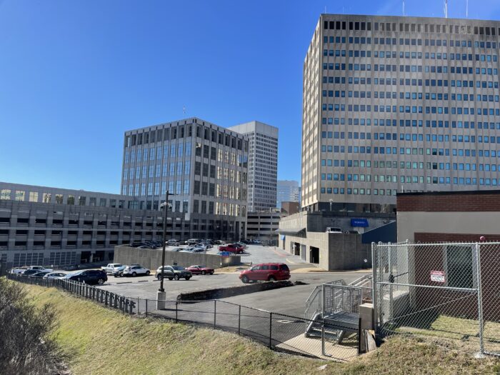
A little farther downhill across East Grace Street is an isolated behemoth built in 1972, the Madison state office building. Its 14 floors are set back a few yards of barely landscaped grounds from Governor Street. Continuing past the Madison tower are entrances into the structure’s garage underbelly.
Finally, upon crossing Bank Street, the city wall returns with the side of the state’s handsome Tyler office building. It grazes the city sidewalks on all its four sides.
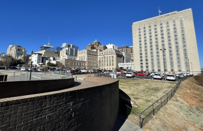
Moving eastward from Governor Street, the surface parking lots below, and behind, Morson’s Row extends to East Grace and Old 14th Street (both allow restricted traffic) and northward to the transportation department’s buildings lining lower East Broad. The grand, 1937 landmark, with its colonnade of engaged columns, is tough, Depression-era architecture. In 1961 the 14-floor annex was built and became a “retaining wall” for a handsome chain of public buildings that stretches from the federal courthouse on North Seventh to North 14th Street.
Although I’m not privy to building condition reports, workforce projections or budgets that will guide the plans for the East Quadrant, the original highway building is a registered historic building. It, and its taller annex should be maintained. The L-shaped tract of land behind them (now surface parking) could be filled — Wall Street-tight — with new office buildings set atop parking garages. This new office complex would wrap around Morson’s Row to front Governor Street. The structure (or structures) would then follow East Grace Street and curve around to Old 14th Street.
The south and eastern facade of this megastructure would open onto a broad, landscaped promenade, a combination sidewalk and terrace following the plateau of Council Chamber Hill. Street-level shops and eateries as well as outdoor amenities would attract customers. But here’s the big thing: The promenade offers delightful vistas of other parts of the city — the Southern States Silos in Manchester, the distinctive tower of the ChildSavers building across Shockoe Bottom on Church Hill, and the great clock tower on Main Street Station. Visitors and locals could visually associate this lost urban pocket with hillsides at similar elevations around town.
This scheme would require architectural savvy and sensitivity, but this arc-shaped office complex and its adjacent hilltop promenade could provide a sun-drenched escape hatch or destination for thousands of employees, residents and visitors populating downtown Richmond. It would also be a hillside attraction, reached by a slight hike from Bank Street up Governor Street, to those traveling the popular Virginia Capital Trail from Jamestown, Williamsburg and other points east.
Vehicular traffic should return to the East Quadrant along a limited route — one-way entering from Broad Street to Old 14th Street (currently open to state employees) and continuing along the promenade on Old 14th, taking a right turn on Grace, and leaving the neighborhood by turning left and down onto Governor. No traffic would be allowed on Governor Street between Grace and Broad.
These steps might contribute to the Eastern Quadrant recovering its roots as a hillside development. Aesthetically it might also be a worthy complement to the Capitol grounds.
Now you might be asking, what about the future for the I-95 side of North 14th Street where the Monroe Building now stands? That tract is enough of a physical break from old Council Chamber Hill that it deserves its own plan. And who knows whether the high-rise will remain or disappear?


I’ve often considered this swath of concrete and asphalt coated land to be butt-ugly and wrote it off as a utilitarian needed bureaucratic necessity for the state government. Ed’s insightful review of it is a helpful first step in its future revival perhaps as it’s inevitable that the state government and VCU will continue to grow its sticks and bricks. I’d like him to take a walk west from the Capitol on East Grace Street. I think that stretch has a lot of potential as a pedestrian mall tieing together the state government buildings to the growing residential areas and… Read more »
It’s cool to hear this oddity of an area of the city get some love. The unique curve, rise, and vistas of this spot are so well articulated here. I occasionally enjoy the challenge of biking up Governor Street when I’m out riding so I love Ed’s notion that it could be a little wide jaunt from the Cap Trail.
Please fact-check the phrase “VCU’s Memorial Hospital”. To my knowledge none of the buildings south of E. Broad are part of VCU’s MCV campus. The building still has the name “Charlotte Williams Memorial Hospital” on Google maps, but I think it hasn’t been used as a medical building in decades.
If I’m thinking of the correct building south of Broad-at least several decades ago there was a wonderful historic surgical amphitheater in that building as well as some charming ‘sun room’ /indoor porch areas to promote the patients’ well being. Hoping some of those features remain.
It’s been an extension of the VDOT complex since the early 90’s and yes, the amphitheater is still there.
At one point when it was still MCV,The VDOT building across from the old wet hospital was MCV south and was part of MCV.That all changed when the new hospital was built .The old E.G.Williams building was MCV north.
My 2g-grandparents, John and Kate Higgins, once owned 219 Governor St. on Morson’s Row. I’ve often thought the development surrounding their home was a slap in the face to those architectural gems, and to the city surrounding it. Likewise, the closure of Governor St. seemed like its purpose was to prevent people from seeing what’s otherwise one of the most beautiful vistas in the entire city. Only in government is commercial office space not yet dying. But death will eventually arrive in that sector, too. Anything that can allow for this quadrant to be opened up and invite the public… Read more »
Someone needs to request the current State draft plans for the East area that have been circulating-if nothing else for the amusement of finding out which FOIA exemption the State will invoke.
Google it, it’s online for free. Published in 2005, updated in 2015.
An article, perhaps in the RTD, indicated there was a new proposed plan circulating among state staff. This was within the last month. Perhaps I misinterpreted but the implication was that there is certainly a plan newer than 2015.
1/2/24 BizSense article refers to the state beginning a new master plan process for the eastern area. Is the plan now being reviewed by staff available online or elsewhere? I’m assuming the 2015 plan is not the same one that will be proposed.
So it seems the state has issued an RFP for a new plan-will look forward to the process, which I hope will be influenced by Edwin Slipek’s views.