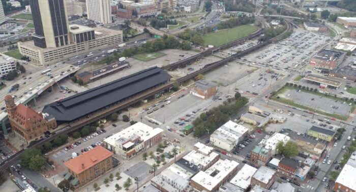
An aerial photo shows Main Street Station and surface parking lots that make up much of Shockoe Bottom.
Following multiple revisions and rounds of back-and-forth between planners and stakeholders, a four-year process to establish a growth guide for the Shockoe area has reached a culmination.
The Richmond Planning Commission on Monday adopted the Shockoe Small Area Plan, a 150-page document in the works since 2020 that’s meant to supplement the citywide Richmond 300 plan.
With the Shockoe plan in place, stakeholders on both the development and preservation sides stressed in a hearing at Monday’s meeting that now is the time to put its recommendations to use.
“It’s time to implement and not keep planning to plan,” said Brian White of Main Street Realty and area group Shockoe Partnership, which consulted on the effort.
Noting the document calls for city-initiated rezonings to accomplish the plan’s land use goals, White added, “We’ve got to implement.”
White and Cyane Crump, executive director of Historic Richmond, addressed the commission before the unanimous vote, both stating that the plan would never fully satisfy all stakeholders but agreeing that the document was as close as they were going to get.
“I think this plan is as close as consensus is attainable,” Crump said, adding that she hopes the plan is put to use “as soon as possible.”
“We may have some differing perspectives with some of the other speakers on how to manage the rezoning. There is some very important historic fabric here which we do not want to lose, which we can’t afford to lose,” she said. “One of the reasons we’re dealing with this plan is because we’ve lost so much. We don’t want to lose more.”

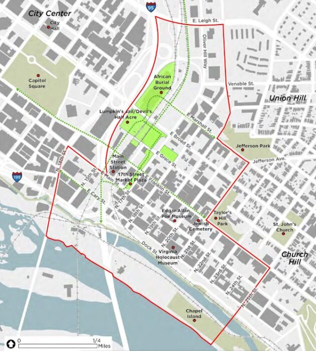
A map of the plan’s study area, outlined in red. The area includes properties planned for the Shockoe Bottom Heritage Campus, which is prominent in the plan. (City documents)
Focusing on Shockoe Bottom and the eastern edge of Shockoe Slip, the plan provides a guide for development centered on the planned Shockoe Bottom Heritage Campus that’s envisioned to be anchored by a national slavery museum. It also documents cultural resources and the area’s history as both the origin of Richmond and the second-largest slave-trading hub in the country.
The plan’s development was slowed partly by the pandemic, with several drafts and reworkings presented to stakeholders and reworked based on feedback. It also hinged on a recently completed hydrology and hydraulic study of the area and the release of the latest Flood Insurance Rate Maps from the Federal Emergency Management Agency.
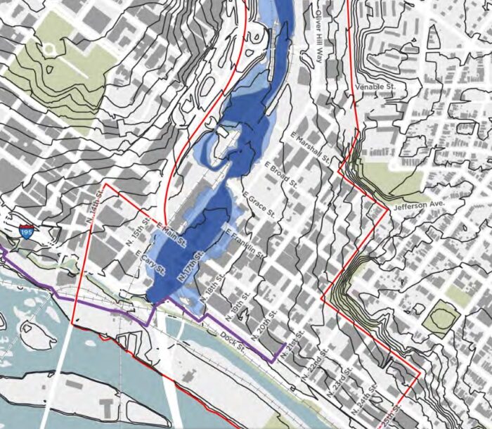
The updated map for Shockoe Bottom includes a delineated floodway, described as the most turbulent part of a floodplain where development is heavily restricted. The hydrology and hydraulic study was aimed at showing what can and cannot be erected above grade in the floodway, which generally follows the historical path of Shockoe Creek and runs through sites that would contribute to the heritage campus.
A final challenge for the plan since the latest draft was presented in May was a revision to language describing a new zoning district that not only would need to be created for parts of Shockoe but also sums up one of the plan’s major goals: to allow for more density in development while also protecting the area’s history and existing street-level character.
The revised language points back to recommended land designations in the Richmond 300 plan, which designates the bulk of the Shockoe area as Destination Mixed-Use, consisting of building heights of at least five stories.
Riverside land across the canal is designated Industrial Mixed-Use, with building heights of three to eight stories. Both designations call for primary uses to include retail, office, multifamily residential, cultural and open space.
The stretch of Main Street and Tobacco Row east of 21st Street is designated Corridor Mixed-Use, with heights ranging from two to 10 stories.
The plan’s roots are tied to the Shockoe Alliance, which was formed in 2018 to create a shared vision for the neighborhood. Group members credited in the plan include Del. Delores McQuinn, City Councilor Cynthia Newbille, Ana Edwards of Sacred Ground Historical Reclamation Project, and David Napier of Shockoe Bottom Business & Neighborhood Association.
Also credited is White, whose Main Street Realty manages several apartment buildings in the area, and is set to manage the 12-story tower under construction at the former Weiman’s Bakery property.
Project management for the plan included Deputy Chief Administrative Officer Sharon Ebert and city planner Kimberly Chen. Consultants included Kimley-Horn & Associates and national engineering firm AECOM.
Planning and Development Review Director Kevin Vonck, who presented the plan Monday, lauded Chen’s work on the effort, which he too described as getting as close to consensus as possible.
Vonck noted that some goals of the plan are already underway, including planning for the heritage campus and development of an interpretive center at Main Street Station, envisioned as a starting point for the campus. An $11 million Mellon Foundation grant was awarded to the city last year to establish the interpretive center.
“I think the speakers are right that this is the best point of consensus that we’re going to get,” Vonck said. “The next stage of actually doing some of the work of rezoning and other tools involved, I think all of the parties are ready to get to work doing that.”
The plan can be viewed on the city’s website.

An aerial photo shows Main Street Station and surface parking lots that make up much of Shockoe Bottom.
Following multiple revisions and rounds of back-and-forth between planners and stakeholders, a four-year process to establish a growth guide for the Shockoe area has reached a culmination.
The Richmond Planning Commission on Monday adopted the Shockoe Small Area Plan, a 150-page document in the works since 2020 that’s meant to supplement the citywide Richmond 300 plan.
With the Shockoe plan in place, stakeholders on both the development and preservation sides stressed in a hearing at Monday’s meeting that now is the time to put its recommendations to use.
“It’s time to implement and not keep planning to plan,” said Brian White of Main Street Realty and area group Shockoe Partnership, which consulted on the effort.
Noting the document calls for city-initiated rezonings to accomplish the plan’s land use goals, White added, “We’ve got to implement.”
White and Cyane Crump, executive director of Historic Richmond, addressed the commission before the unanimous vote, both stating that the plan would never fully satisfy all stakeholders but agreeing that the document was as close as they were going to get.
“I think this plan is as close as consensus is attainable,” Crump said, adding that she hopes the plan is put to use “as soon as possible.”
“We may have some differing perspectives with some of the other speakers on how to manage the rezoning. There is some very important historic fabric here which we do not want to lose, which we can’t afford to lose,” she said. “One of the reasons we’re dealing with this plan is because we’ve lost so much. We don’t want to lose more.”

A map of the plan’s study area, outlined in red. The area includes properties planned for the Shockoe Bottom Heritage Campus, which is prominent in the plan. (City documents)
Focusing on Shockoe Bottom and the eastern edge of Shockoe Slip, the plan provides a guide for development centered on the planned Shockoe Bottom Heritage Campus that’s envisioned to be anchored by a national slavery museum. It also documents cultural resources and the area’s history as both the origin of Richmond and the second-largest slave-trading hub in the country.
The plan’s development was slowed partly by the pandemic, with several drafts and reworkings presented to stakeholders and reworked based on feedback. It also hinged on a recently completed hydrology and hydraulic study of the area and the release of the latest Flood Insurance Rate Maps from the Federal Emergency Management Agency.
The updated map for Shockoe Bottom includes a delineated floodway, described as the most turbulent part of a floodplain where development is heavily restricted. The hydrology and hydraulic study was aimed at showing what can and cannot be erected above grade in the floodway, which generally follows the historical path of Shockoe Creek and runs through sites that would contribute to the heritage campus.
A final challenge for the plan since the latest draft was presented in May was a revision to language describing a new zoning district that not only would need to be created for parts of Shockoe but also sums up one of the plan’s major goals: to allow for more density in development while also protecting the area’s history and existing street-level character.
The revised language points back to recommended land designations in the Richmond 300 plan, which designates the bulk of the Shockoe area as Destination Mixed-Use, consisting of building heights of at least five stories.
Riverside land across the canal is designated Industrial Mixed-Use, with building heights of three to eight stories. Both designations call for primary uses to include retail, office, multifamily residential, cultural and open space.
The stretch of Main Street and Tobacco Row east of 21st Street is designated Corridor Mixed-Use, with heights ranging from two to 10 stories.
The plan’s roots are tied to the Shockoe Alliance, which was formed in 2018 to create a shared vision for the neighborhood. Group members credited in the plan include Del. Delores McQuinn, City Councilor Cynthia Newbille, Ana Edwards of Sacred Ground Historical Reclamation Project, and David Napier of Shockoe Bottom Business & Neighborhood Association.
Also credited is White, whose Main Street Realty manages several apartment buildings in the area, and is set to manage the 12-story tower under construction at the former Weiman’s Bakery property.
Project management for the plan included Deputy Chief Administrative Officer Sharon Ebert and city planner Kimberly Chen. Consultants included Kimley-Horn & Associates and national engineering firm AECOM.
Planning and Development Review Director Kevin Vonck, who presented the plan Monday, lauded Chen’s work on the effort, which he too described as getting as close to consensus as possible.
Vonck noted that some goals of the plan are already underway, including planning for the heritage campus and development of an interpretive center at Main Street Station, envisioned as a starting point for the campus. An $11 million Mellon Foundation grant was awarded to the city last year to establish the interpretive center.
“I think the speakers are right that this is the best point of consensus that we’re going to get,” Vonck said. “The next stage of actually doing some of the work of rezoning and other tools involved, I think all of the parties are ready to get to work doing that.”
The plan can be viewed on the city’s website.


Interactive space…. would love to see someone actually do this center but have jo faith the city will get it done. Been over 10 years of talk and monies with little to show. Now for an $11M donation we get this still not clear entity that is going to simply be the basement retail space that’s never been built out, that’s been occasionally used for art fairs, and it’s behind the existing sparsely visited state welcome center.
The plan terminates at the 14th Street bridge. Is there a separate plan for going south across the river?
Bruce – I don’t believe there is a Manchester-specific SAP at this time.
I hope the Slavery museum shines a light on human trafficking and the modern day slave trade, because this is still an enormous problem in the world.