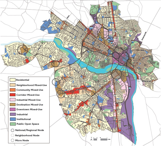
The latest version of the Richmond 300 plan’s future land use map includes the new Community Mixed-Use designation, in orange. (Images courtesy of Richmond 300)
Four years’ worth of work to update Richmond’s 20-year master plan could come to fruition with a City Council vote tonight.
The Richmond 300 plan, meant to guide growth through the city’s tricentennial in 2037, is slated to formally be considered for adoption at the council’s regular meeting, which starts at 6 p.m.
The nearly 250-page document, which pulls from and consolidates previously approved plans while adding new recommendations that could influence future growth decisions, has been steadily making its way to the council since it was released in draft form earlier this year. The Planning Commission endorsed it, and presentations have been made to council members in recent committee and regular meetings.
But tonight is the first time the council will consider adopting the plan that’s intended to guide land use and zoning decisions over the next two decades.
Overseen by an advisory council headed by Planning Commission Chairman Rodney Poole, the years-long effort has been guided by city planning staff and consultants from national engineering firm AECOM, who have held numerous workshops and conducted multiple surveys to solicit input from the public that was used to help shape the final proposal.
Among some of the plan’s most head-turning suggestions: building a bridge deck across the interstate to reconnect Jackson Ward; focusing development along Hermitage Road with a relocated baseball stadium and park; returning Southside Plaza to its roots; and reimagining Stony Point Fashion Park.
Public process
Feedback received through a series of virtual summits, as well as from surveys and other correspondence, have driven some revisions to the plan’s initial draft. Those include a new land use category, called Community Mixed-Use, which is now reflected on parts of the plan’s future land use map.
The new designation — one of 10 in the plan that are intended to guide development and future zoning decisions — is applied in areas of the city including Patterson Avenue’s crossroads with Three Chopt Road and Libbie Avenue, parts of the Fan, MacArthur Avenue in Bellevue, Brookland Park Boulevard and the Six Points area. Previous designations in some of those areas had recommended building heights of up to six stories and varying densities.

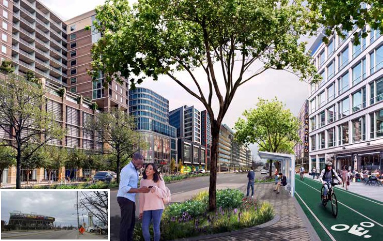
A conceptual rendering in Richmond 300 of how Arthur Ashe Boulevard could develop after The Diamond, pictured lower left, is relocated.
Other mapping changes were made in areas including Randolph, Oregon Hill, Shockoe and Rocketts Landing. Randolph was largely changed from Neighborhood Mixed-Use to Residential, as feedback from the community indicated that its past mixed-use character was not expected to return or be encouraged.
Other revisions to the plan include the addition of implementation and reporting metrics that are designed to show how the plan is being applied and keep its recommendations relevant and up-to-date over time.
Chances for the public to weigh in on the final proposal have been provided in virtual workshops held over the course of the pandemic, as well as in hearings before the Planning Commission and the council’s Land Use, Housing and Transportation Standing Committee, which sent the plan to tonight’s meeting with no recommendation.
A hearing preceding a vote tonight provides one more chance for public scrutiny of the plan. Adoption would repeal the city’s 2000 master plan but preserve amendments including the Riverfront Plan, the VUU/Chamberlayne Neighborhood Plan, the Pulse Corridor Plan, the Riverfront Plan, the Public Art Master Plan and the James River Park Systems Master Plan.
Concerns in final stretch
Several observers through the process have scrutinized the document up until the end. Among them most recently: a group of neighborhood and civic associations that in recent months pushed back against the latest round of proposed zoning changes tied to the Pulse Corridor Plan — one of the plans that’s reflected in and helped inform Richmond 300.
The city recently withdrew those proposals for areas generally across Broad Street from the Fan, but Jonathan Marcus, a West Grace Street resident and president of RVA Coalition of Concerned Civic Associations, said the group is now concerned that similar proposals for higher-density development in those areas is promoted in Richmond 300.
Marcus pointed to apparent discrepancies between Richmond 300 and the Pulse Corridor Plan, specifically in parts of their respective future land-use plans. While largely similar in their land use designations, save for some different names to describe them, the two maps do show some differences in relation to parts of the Pulse corridor, including along the stretch that was proposed for the withdrawn rezonings.

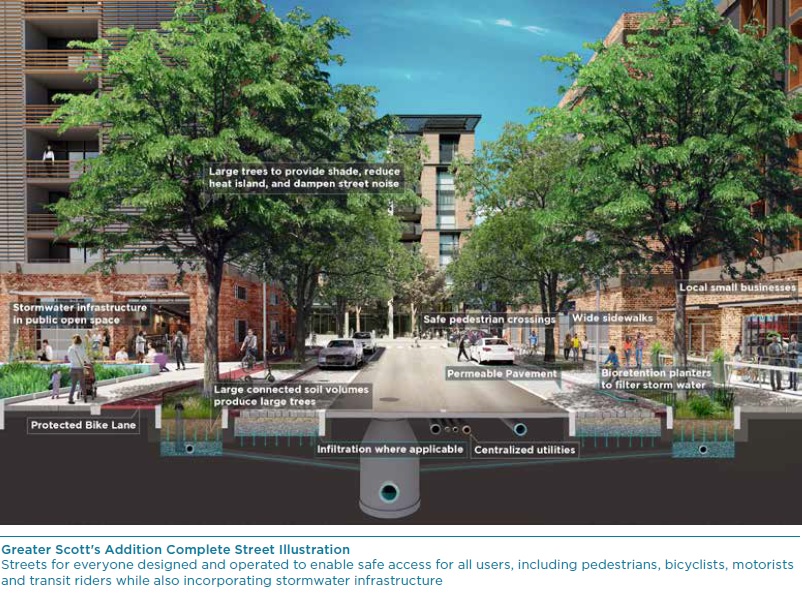
A rendering of the plan’s “Complete Streets” approach that also informs its “Great Streets” suggestions.
In the Pulse plan, a designation called Nodal Mixed-Use, which calls for high-density development with building heights of at least five stories, is recommended along the north side of Broad at Belvidere Street, and generally from Lombardy Street to Arthur Ashe Boulevard, not including the DMV building and the science and children’s museums.
In Richmond 300, a similar designation called Destination Mixed-Use, which likewise calls for higher density with five-story minimums, stretches along Broad from Belvidere to Harrison Street, several blocks farther west than what’s shown in the Pulse plan.
The Richmond 300 map also shows a designation called Corridor Mixed-Use along the Fan side of the Pulse corridor along Broad. That designation, in both plans, calls for medium density development with buildings two to 10 stories in height, with additional height “when appropriate.”
While the group has since said it’s amenable to 12-story buildings in the Pulse rezonings, an initial plan for such building heights along the Fan side of Broad was removed from the Pulse proposal in response to concerns from the Historic West Grace Street Association — one of the eight associations that make up the group.
“It appears that Richmond 300 is kind of an end-around on those very ordinances,” Marcus said last week, referring to the recent Pulse zoning proposals. “It’s great that the three ordinances have been withdrawn, but … it’s the same problem under a much bigger umbrella.”
‘Land use is not zoning’
Mark Olinger, the city’s planning director who’s been leading both Richmond 300’s development and the Pulse rezonings, said the differences in the maps in regard to Broad near Belvidere are more in name than substance.
He noted that the existing zoning for that area, on the Carver side of Broad, is B-4 Central Business District, which determines building heights based on a four-to-one “inclined plane” ratio, in which 4 feet in height is allowed for every 1 foot in width from the center of adjacent right-of-way. In some areas along Broad, that could allow for building heights of 20 stories or more, but Olinger said what’s possible there now is consistent with what’s reflected in both plans’ maps.
Olinger, who said he’ll be explaining such differences in a presentation to the council at its 4 p.m. informal meeting, also emphasized that both Richmond 300 and the Pulse Corridor Plan deal with land use designations that shouldn’t be confused with rezoning proposals.
“Land use is not zoning,” Olinger said last week. “I think what some of the folks are concerned about, they’re saying you’ve got Destination Mixed-Use here; that means you’re going to do B-4 and everything. That’s not what that means at all.
“We changed from Nodal Mixed-Use (in the Pulse plan) to Destination Mixed-Use (in Richmond 300) to change the language of the discussion,” Olinger said, adding that the “destination” designation was also applied in Shockoe Bottom, as a result of feedback from the Shockoe Alliance group and others. In Shockoe’s case, the change was meant to reflect that group’s efforts to make the Bottom more of a destination for cultural and civic engagement.
“There is a change in language,” Olinger said. “Essentially, there is no change in bulk and mass requirements between the two plans.”
The final Richmond 300 proposal and related documents can be viewed on the plan’s website.

The latest version of the Richmond 300 plan’s future land use map includes the new Community Mixed-Use designation, in orange. (Images courtesy of Richmond 300)
Four years’ worth of work to update Richmond’s 20-year master plan could come to fruition with a City Council vote tonight.
The Richmond 300 plan, meant to guide growth through the city’s tricentennial in 2037, is slated to formally be considered for adoption at the council’s regular meeting, which starts at 6 p.m.
The nearly 250-page document, which pulls from and consolidates previously approved plans while adding new recommendations that could influence future growth decisions, has been steadily making its way to the council since it was released in draft form earlier this year. The Planning Commission endorsed it, and presentations have been made to council members in recent committee and regular meetings.
But tonight is the first time the council will consider adopting the plan that’s intended to guide land use and zoning decisions over the next two decades.
Overseen by an advisory council headed by Planning Commission Chairman Rodney Poole, the years-long effort has been guided by city planning staff and consultants from national engineering firm AECOM, who have held numerous workshops and conducted multiple surveys to solicit input from the public that was used to help shape the final proposal.
Among some of the plan’s most head-turning suggestions: building a bridge deck across the interstate to reconnect Jackson Ward; focusing development along Hermitage Road with a relocated baseball stadium and park; returning Southside Plaza to its roots; and reimagining Stony Point Fashion Park.
Public process
Feedback received through a series of virtual summits, as well as from surveys and other correspondence, have driven some revisions to the plan’s initial draft. Those include a new land use category, called Community Mixed-Use, which is now reflected on parts of the plan’s future land use map.
The new designation — one of 10 in the plan that are intended to guide development and future zoning decisions — is applied in areas of the city including Patterson Avenue’s crossroads with Three Chopt Road and Libbie Avenue, parts of the Fan, MacArthur Avenue in Bellevue, Brookland Park Boulevard and the Six Points area. Previous designations in some of those areas had recommended building heights of up to six stories and varying densities.

A conceptual rendering in Richmond 300 of how Arthur Ashe Boulevard could develop after The Diamond, pictured lower left, is relocated.
Other mapping changes were made in areas including Randolph, Oregon Hill, Shockoe and Rocketts Landing. Randolph was largely changed from Neighborhood Mixed-Use to Residential, as feedback from the community indicated that its past mixed-use character was not expected to return or be encouraged.
Other revisions to the plan include the addition of implementation and reporting metrics that are designed to show how the plan is being applied and keep its recommendations relevant and up-to-date over time.
Chances for the public to weigh in on the final proposal have been provided in virtual workshops held over the course of the pandemic, as well as in hearings before the Planning Commission and the council’s Land Use, Housing and Transportation Standing Committee, which sent the plan to tonight’s meeting with no recommendation.
A hearing preceding a vote tonight provides one more chance for public scrutiny of the plan. Adoption would repeal the city’s 2000 master plan but preserve amendments including the Riverfront Plan, the VUU/Chamberlayne Neighborhood Plan, the Pulse Corridor Plan, the Riverfront Plan, the Public Art Master Plan and the James River Park Systems Master Plan.
Concerns in final stretch
Several observers through the process have scrutinized the document up until the end. Among them most recently: a group of neighborhood and civic associations that in recent months pushed back against the latest round of proposed zoning changes tied to the Pulse Corridor Plan — one of the plans that’s reflected in and helped inform Richmond 300.
The city recently withdrew those proposals for areas generally across Broad Street from the Fan, but Jonathan Marcus, a West Grace Street resident and president of RVA Coalition of Concerned Civic Associations, said the group is now concerned that similar proposals for higher-density development in those areas is promoted in Richmond 300.
Marcus pointed to apparent discrepancies between Richmond 300 and the Pulse Corridor Plan, specifically in parts of their respective future land-use plans. While largely similar in their land use designations, save for some different names to describe them, the two maps do show some differences in relation to parts of the Pulse corridor, including along the stretch that was proposed for the withdrawn rezonings.

A rendering of the plan’s “Complete Streets” approach that also informs its “Great Streets” suggestions.
In the Pulse plan, a designation called Nodal Mixed-Use, which calls for high-density development with building heights of at least five stories, is recommended along the north side of Broad at Belvidere Street, and generally from Lombardy Street to Arthur Ashe Boulevard, not including the DMV building and the science and children’s museums.
In Richmond 300, a similar designation called Destination Mixed-Use, which likewise calls for higher density with five-story minimums, stretches along Broad from Belvidere to Harrison Street, several blocks farther west than what’s shown in the Pulse plan.
The Richmond 300 map also shows a designation called Corridor Mixed-Use along the Fan side of the Pulse corridor along Broad. That designation, in both plans, calls for medium density development with buildings two to 10 stories in height, with additional height “when appropriate.”
While the group has since said it’s amenable to 12-story buildings in the Pulse rezonings, an initial plan for such building heights along the Fan side of Broad was removed from the Pulse proposal in response to concerns from the Historic West Grace Street Association — one of the eight associations that make up the group.
“It appears that Richmond 300 is kind of an end-around on those very ordinances,” Marcus said last week, referring to the recent Pulse zoning proposals. “It’s great that the three ordinances have been withdrawn, but … it’s the same problem under a much bigger umbrella.”
‘Land use is not zoning’
Mark Olinger, the city’s planning director who’s been leading both Richmond 300’s development and the Pulse rezonings, said the differences in the maps in regard to Broad near Belvidere are more in name than substance.
He noted that the existing zoning for that area, on the Carver side of Broad, is B-4 Central Business District, which determines building heights based on a four-to-one “inclined plane” ratio, in which 4 feet in height is allowed for every 1 foot in width from the center of adjacent right-of-way. In some areas along Broad, that could allow for building heights of 20 stories or more, but Olinger said what’s possible there now is consistent with what’s reflected in both plans’ maps.
Olinger, who said he’ll be explaining such differences in a presentation to the council at its 4 p.m. informal meeting, also emphasized that both Richmond 300 and the Pulse Corridor Plan deal with land use designations that shouldn’t be confused with rezoning proposals.
“Land use is not zoning,” Olinger said last week. “I think what some of the folks are concerned about, they’re saying you’ve got Destination Mixed-Use here; that means you’re going to do B-4 and everything. That’s not what that means at all.
“We changed from Nodal Mixed-Use (in the Pulse plan) to Destination Mixed-Use (in Richmond 300) to change the language of the discussion,” Olinger said, adding that the “destination” designation was also applied in Shockoe Bottom, as a result of feedback from the Shockoe Alliance group and others. In Shockoe’s case, the change was meant to reflect that group’s efforts to make the Bottom more of a destination for cultural and civic engagement.
“There is a change in language,” Olinger said. “Essentially, there is no change in bulk and mass requirements between the two plans.”
The final Richmond 300 proposal and related documents can be viewed on the plan’s website.


A well written and thorough article. Thank you. The proposed higher density in the plan looks (to me, any way) a lot like the Pearl District in Portland, Oregon.
It looks like renderings in the Downtown Master plan, of which nothing yet built since its adoption or street on either side of the river in that plan looks like its renderings.
Notice how this article mentions how Randolph was able to get its future land use changed, but not Oregon Hill. We have been targeted, and this plan may very well end our historic neighborhood- not tomorrow but over the next few decades.
Scott is Richmond Famous for good reason, he has never let reality intimidate him or affect his views.
Keep in mind how Richmond City Council is pushing through the Richmond300 master plan tonight, during a pandemic, close to a holiday, despite Virginia Attorney General calling for municipalities to suspend all non-life-threatening business, and specifically land-use issues during the pandemic.
https://www.venable.com/insights/publications/2020/03/potential-restriction-on-land-use-approvals-by
That is the MO of the city. City Planning will always do what City Planning wants to do. Community meetings for feedback are merely gestures to placate the complainants saying that they didn’t get input. Watched it happen with the Libbie/Grove/Patterson corridor so when it comes to the city listening to its communities…mmm not much faith there.
That rendering looks just like you are driving through West Broad Village in Short Pump.